

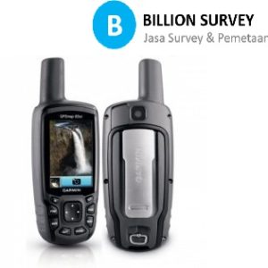
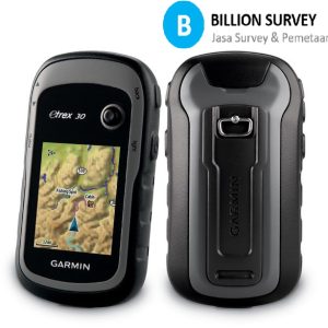
Deskripsi
Garmin eTrex 10 sangat cocok untuk Menandai lokasi (marking point) dan Merekam jejak (Track log). Dapat digunakan untuk memperkirakan luas suatu wilayah lebih cepat, hasil jejak yang direkam dapat dicetak melalui software keluaran Garmin.
Features :
Physical & Performance:
Unit dimensions, WxHxD: 2.1″ x 4.0″ x 1.3″ (5.4 x 10.3 x 3.3 cm)
Display size, WxH: 1.4″ x 1.7″ (3.6 x 4.3 cm); 2.2″ diag (5.6 cm)
Display resolution, WxH: 128 x 160 pixels
Display type: transflective, monochrome
Weight: 5 oz (141.7 g) with batteries
Battery: 2 AA batteries (not included); NiMH or Lithium recommended
Battery life: 25 hours
Waterproof: yes (IPX7)
Floats: no
High-sensitivity receiver: yes
Interface: USB
Maps & Memory:
Basemap: yes
Preloaded maps: no
Ability to add maps: no
Built-in memory: no
Accepts data cards: no
Waypoints/favorites/locations: 1000
Routes: 50
Track log: 10,000 points, 100 saved tracks
Features & Benefits:
Automatic routing (turn by turn routing on roads): no
Electronic compass: no
Touchscreen: no
Barometric altimeter: no
Camera: no
Geocaching-friendly: yes (paperless)
Custom maps compatible: no
Photo navigation (navigate to geotagged photos): no
Outdoor GPS games: no
Hunt/fish calendar: yes
Sun and moon information: yes
Tide tables: no
Area calculation: yes
Custom POIs (ability to add additional points of interest): yes
Unit-to-unit transfer (shares data wirelessly with similar units): no
Picture viewer: no
Garmin Connect™ compatible (online community where you analyze, categorize and share data): yes
What’s in the Box:
eTrex 10
USB cable
Manual

Ulasan
Belum ada ulasan.